
The Regional Integrated Transportation Information System (RITIS) is an automated transportation data platform that includes many visual analytics tools to help agencies to gain situational awareness, measure performance, and communicate information with other agencies and the public.
The Probe Data Analytics Suite allows agencies to support operations, planning, analysis, research, and generation of performance measures using probe data fused with other agency transportation data.

The CATT Lab developed the Work Zone Performance Monitoring (WZPM) tool for Maryland State Highway Administration to assist in compliance with the requirements of the Final Rule on Work Zone Safety and Mobility.

The CATT Lab has designed a series of applications for the Maryland State Highway Administration, Motor Carrier Division, to help them monitor their virtual weigh station (VWS) sites.

The Incident Timeline Tool provides for the visualization of detailed real-time and historic traffic management center incident data.

The CHART Reporting application allows managers and operations staff at the Maryland Department of Transportation’s Coordinated Highway Action Response Team (CHART) to quickly answer questions about their real-time and archived operational conditions.

Comparing trees is difficult. To address this, we present TreeVersity, an interactive visualization that gives users powerful tools to detect both node value changes and topological differences.

Explore and Visualize Crashes (EVC) is a web-based application that gives users the ability to query accident data directly from a central database, from any computer, and analyze it through a series of connected visualizations. EVC was designed with user needs in mind and accommodates computer novices as well as proficient users. EVC is unique in that it does not require the user to be familiar with the structure of the data to be able to explore it.

The Detector Explorer is a robust tool that makes the data recorded by traffic detectors easily understandable through a series of graphical reports, charts, and tables all exportable to Microsoft Excel.

The CATT Lab has integrated all Clarus Data into the Regional Integrated Transportation Information System (RITIS) for real-time situational awareness and historical safety data analysis.
Temporal data sets often present an interesting characteristic of being linear in nature, but contain cyclic patterns that are not effectively conveyed by conventional linear visualizations and are often more interesting than the linearity of the data itself. The Time Spiral, an interactive web-based tool, employs a visualization technique that allows these cyclic patterns to take center stage, while at the same time simplifying the identification of breaks or anomalies in the data set being investigated.

A novel, web-based, visual analytics tool called the Incident Cluster Explorer (ICE) was developed as an application that affords sophisticated yet user-friendly analysis of transportation incident datasets. Interactive maps, histograms, two-dimensional plots and parallel coordinates plots are four featured visualizations that were integrated together into ICE to allow users to interact with and see relationships between multiple visualizations.
When dealing with data sets containing hundreds of variables, it is often extremely difficult, if not impossible, to quickly discover important and significant relationships that exist among the various data points. The ArcChart, an interactive, web-based circular dependency graph, was developed to give analysts the ability to visually identify these dependencies and links between any categorical, temporal, or spatial variables in a given data set.

The 4D Virtual Globe application is an initiative effort by the CATT Lab to weave real-time geospatial data from different sources into one coherent big picture. This visualization tool has been developed to provide incident management personnel, emergency management personnel, and the general public with the means to achieve situational awareness in as close to a real-world setting as possible.

As air traffic rises at a rapid rate, congestion in National Airspace (NAS) becomes a primary concern of Air Traffic Control (ATC). This increase in traffic is pushing the limits of what controllers can handle in a given airspace. Sky Graph provides a stereoscopic 3-dimensional environment where airspace designers can modify existing NAS elements as well as visually analyze historical flight and airspace data.
Training of traffic control personnel, emergency management personnel, and first-responders is essential in effectively managing the consequences of road construction, traffic incidents, natural disasters, acts of terrorism, and other large-scale emergencies. In collaboration with The Eastern Transportation Coalition, the CATT Lab has developed both a Core Competencies web application and a massively multiplayer online training simulation to be used together as a low-cost, high-impact supplemental program to train traffic management personnel and first-responders to react more efficiently to traffic incidents.
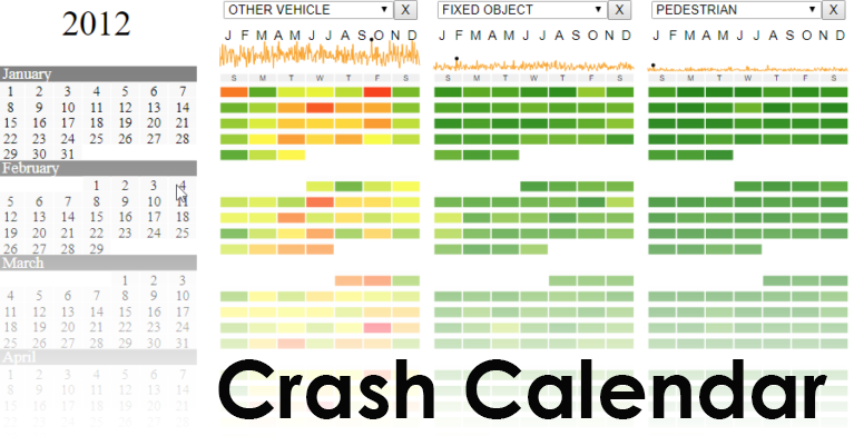
Working with Joni Graves at the University of Wisconsin, we created a digital interpretation of her Crash Calendar. The Wisconsin Bureau of Transportation Safety (BOTS) uses Mrs. Graves’ original Crash Calendar to analyze what factors contribute to crashes and to foster conversation about how to reduces crash rates. Our Crash Calendar is seeded with data from the Maryland Department of Transportation’s CHART system to help bring the kinds of insights that Wisconsin is making over to the Old Line State.
